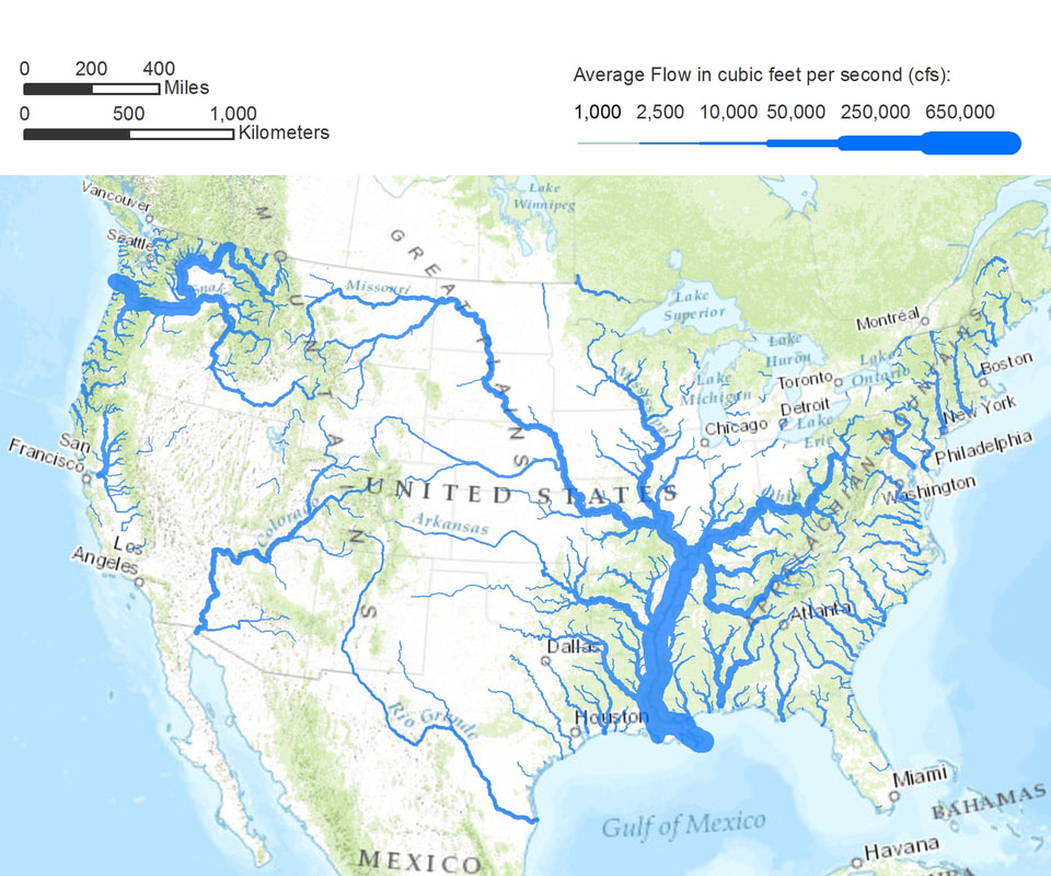
 On the heels of the previous blog, Overview, take a look at a map of where you live, preferably in satellite view. If you are like most people, you live in a densely populated area. But why is your home region located where it is? Take a closer look, and you will notice a nearby river, lake, or ocean, or combination of these, not only providing access to drinkable water but also enabling the transport of goods long before the availability of railroads, when the only alternative was costly overland transport via wagon and pack animal. New York City sits at the nexus of the Hudson River and the Atlantic Ocean, and its location near major waterways is key to its prominence on the world stage. In Gotham, Edwin Burrows and Mike Wallace describe some of the geographic features of New York that led New York to become "the principal link between the United States and world markets." Its location on the Atlantic, with a deep harbor accessible to the open ocean and rarely impeded by ice, led to regional and global commerce, with markets in the West Indies and Europe for farm products and cotton. By contrast, Boston's Harbor was often blocked by ice in the winter, and Philadelphia, 100 miles from the mouth of Delaware Bay, was accessible to large vessels only during flood tide. But it was the Hudson that connected New York City to the interior of the content and led to the development of a nation. Canals constructed in the 1790s linked the Hudson with Lake Champlain and Lake Ontario, extending the the reach of New York City into hinterlands along Lake Erie and western Pennsylvania. Completed in 1825, and later enlarged, the Erie Canal—America’s first super highway—contributed to New York City’s global ascendancy by creating an inland navigable waterway connecting the Great Lakes to the Atlantic and enabling the transport of inland mining and agricultural goods to overseas markets. This engineering feat was made possible by the geologic good fortune of New York State: an east-west gap in the Appalachian Mountain chain, along the Mohawk River valley between the Adirondack and Catskill Mountains. Extending over 1,500 miles, 400 miles inland from the Atlantic Coast, the Appalachians were a considerable barrier to western migration and trade, with only five east-west gaps allowing travel by pack animal. Notice other cities central to manufacturing: Duluth, Minnesota, on the western edge of Lake Superior, in the heartland of North America, 1,500 miles from the Atlantic coast in a region rich in iron ore and accessible to the beaver fur trade; Chicago and Milwaukee, abutting Lake Michigan; Detroit on Lake Erie, via the Detroit River; Cleveland and Toledo on Lake Erie too. These interior cities are port cities because of their access to the Atlantic, first via the Erie Canal and later via the Great Lakes Saint Lawrence Seaway, more recently named "Hwy H2O". Consider Minneapolis, with access to the Gulf of Mexico via the Mississippi River; Saint Louis, at the juncture of the Mississippi and Missouri Rivers, the gateway to the west, with the Missouri extending to its headwaters in the Rocky Mountains in Montana; and New Orleans, on the Gulf of Mexico at the Mississippi estuary. And take note of countless cities and towns along major rivers of the U.S.: the Connecticut and Housatonic, Mohawk, Delaware and Schuylkill, Monongahela, Susquehanna, Allegheny, Ohio, Platte, Arkansas, Tennessee, Savannah, and Potomac, supporting the manufacturing of textiles, lumber and paper mills, and steel and transport of goods. The same waterways that enabled industry and transport, which in turn gave rise to cities and towns, attracted our country’s original inhabitants; what is now Manhattan, Philadelphia, Washington DC, Detroit was once occupied by other nations--Manhattoes, Lenape, Erie, Illinois, Pequot, Mahican, Ojibwa, Delaware, Powhatan, Huron, and Cherokee, to name a few. Contemporary place-names, rolling off our tongues with such familiarity that we rarely think about their original references, are reminders of the legacy of these earliest inhabitants. And of course, proximity to water isn’t unique to US cities. Paris’s began on an island in the Seine; London on the Thames; Istanbul on the Bosphorus; Agra and New Delhi on the Yumana. And grade school children learn of the “cradle of civilization” developing between the Tigris and Euphrates rivers. These days, with water magically appearing out of our kitchen and bathroom faucets and goods available to us in stores and via online delivery, it's easy to disregard the impact of nearby waterways and their significance in the location of our major towns and cities. But, towns and cities are located where they are because of the availability of resources and transportation, with oceans, rivers, and lakes functioning like giant vascular systems enabling access to resources and materials and the exchange of goods, long before the invention of the railroad and air travel. Take a moment and consider your nearby waterways, and how they helped shape the place where you live.
1 Comment
|
About this Blog
Hi! I'm Nancy Kopans, founder of Urban Edge Forest Therapy. Join me on an adventure to discover creative ways to connect with nature in your daily life, ways that are inspired by urban surroundings that can reveal unexpected beauty, with the potential to ignite a sense of wonder. Archives
April 2023
Categories
All
|

 RSS Feed