
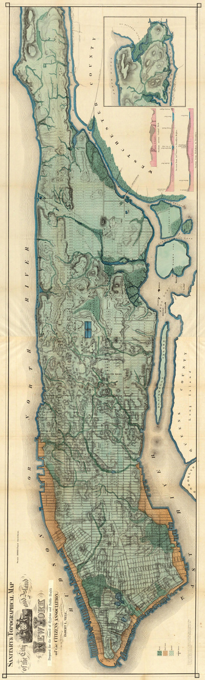
 Egbert L. Viele's "water map" of 1874 Egbert L. Viele's "water map" of 1874 A New Yorker from the 1700s with an eye for watercourses returning today would notice much that is similar to 300 years ago. The Hudson, East, and Harlem rivers still surround Manhattan like a moat surrounding a castle, although landfill has altered the Hudson coastline along the southern tip of Manhattan and the Harlem River was expanded in the 1890s to traverse the tidal straight that separated Manhattan and the Bronx. Newtown Creek still separates what are now Brooklyn and Queens, and the Arthur Kill flows between New Jersey and Staten Island. Flushing and Little Neck bays still border northern Queens, and the Atlantic Ocean borders Brooklyn and Staten Island, leading through the Verrazano narrows to one of the great natural harbors, even if much of the shipping traffic has located to Elizabeth, New Jersey. But for all the still-visible waterways bordering New York City and demarcating its boroughs, much would appear different. Countless swamps, streams, springs, and ponds have been altered. Some still exist, but have been tamed by engineering and relegated subterranean realms, becoming part of New York City's sewer system. Perhaps most notable to our visitor would be the disappearance of the Collect Pond, the source of fresh water for Manhattan’s early European settlers and the Lenape people. What was once a place of drinking water is now a place of law and order. 60 Centre Street, the New York County Courthouse, was constructed over the pond's site, with pumps continually at work to prevent basement flooding. The 2014 redesign of "Collect Pond Park", near the courthouse and featuring a reflecting pool, now highlights this important water resource which was submerged in 1825. Like the Viele map, shown here and completed in 1874, the Nicolls map, completed in 1668 and referenced in John Kieran's 1959 book A Natural History of New York, shows numerous streams traversing Manhattan. As Kieran notes, "the Saw Kill, ran from what is now Park Avenue in the East River at about 75th Street. Montague's Brook ran from what is now 120th Street and Eighth Avenue in a zigzag course to enter into the East River at about 107th Street. It even had an island in it between Lexington and Third Avenues.... Minetta--or Manetta--Brook wandered through the Greenwich Village area...." To put it mildly, watercourse were abundant throughout New York City, and they still are, even if they aren't readily visible. In his terrific website and other writings intrepid urban explorer Steve Duncan identifies hidden watercourse throughout New York City. He notes that Manetta Brook now runs through a 12-foot wide sewer tunnel under Clarkson Street; the spring-fed Collect Pond, described above, in turn fed the marshland over which now sits Canal Street, which in turn became New York's first underground sewer; Sunfish Pond was located between what is now Madison and Lexington Avenues and 31st and 32nd Streets, with Sunfish Creek flowing from the pond to the East River. Tibbetts Brook, which ran near what would become Van Cortland Park in 1899, became what is now the largest sewer line in the Bronx, with the mill pond created when Jacobus Van Cortland dammed the brook in 1699 now a decorative pond in the park. Freshwater resources like Sunswick Creek in Queens and Wallabout Brook in Brooklyn are among the many other waterways that helped make the New York area habitable. Hidden Waters of New York City, by Sergey Kadinsky, also describes New York City's many waterways. Manetta Brook, he writes, is thought to derive from the Algonquin term "manitou or "spirit". Although the brook is now submerged, Minetta Triangle, a small park in Greenwich Village, depicts images of trout along its paths, homage to fish once found in the brook. The location of the Jacqueline Kennedy Onassis Reservoir was once a freshwater wetland from which a branch of the Saw Kill River drained. Signals and indicators of once-visible watercourses remain in place names: Spring Street, Canal Street, Water Street, to name a few. And, though submerged and encased underground, often through marvels of 200-year old brickwork, hidden watercourses routinely challenge urbanization and with it our sense of our own primacy and control over nature. From the early days of New York City's urbanization to present, development plans have been challenged by underground water: Manetta Creek challenging construction in Greenwich Village; the original Waldorf Astoria requiring continual pumping to contain seepage from an underground pond; the renovation of multi-million dollar townhouse on Manhattan's Upper West Side threatened by an underground stream; and according to Duncan buildings near Washington Square Park (2 Fifth Avenue and 33 Washington Square West) once housed fountains displaying water from underground springs. Even in a place as urbanized as New York City, nature courses throughout, submerged underground but still forcefully present, like primal, subconscious thoughts. Skilled engineering may tame and contain New York City's watercourses, but continual effort is needed to control what is ultimately a force bigger than ourselves.
0 Comments
Leave a Reply. |
About this Blog
Hi! I'm Nancy Kopans, founder of Urban Edge Forest Therapy. Join me on an adventure to discover creative ways to connect with nature in your daily life, ways that are inspired by urban surroundings that can reveal unexpected beauty, with the potential to ignite a sense of wonder. Archives
April 2023
Categories
All
|
 RSS Feed